|
|
|
Community and Economic Development – Blog by UNC School of Government https://ced.sog.unc.edu Practical Tools for CED: What Social Network Maps Can OfferBy Maureen BernerPublished January 19, 2021
Last May, the following message went out over the Food Policy Network’s (FPN) listserv. “We are working to put together a process for network mapping one of our local food policy councils’ COVID response efforts. (The) purposes are to document the networks that were developed and the associated outcomes, as well as to use the map to help solidify The online discussion that followed highlighted the great advances being made in using different kinds of mapping tools. Planners, GIS and IT professionals and others have used geographic mapping tools for years and produce incredible results. But are there practical tools for other areas of government and community groups that bring the value of mapping to local problems? FPN members from across the country made ‘shout outs’ to tools. Most were simple to use and effective for their local government/community food system needs around social connections, not geography. One type of tool is a social capital or network map. This allows you to visually show how various pieces (or people or organizations) in any process or network are connected. It is not based on physical maps – at least not initially. Imagine being able to show in one image how connections between various nonprofits are working together to provide basic needs for families affected by COVID. A single map could illustrate who is coordinating with who, such as a local charity thrift store, homeless shelter, and housing agency collaborating – helping newly evicted individuals get into a furnished place quickly. It can also show what agencies are serving as natural coordinating points. An office may be isolated in terms of knowledge and influence, and therefore less effective, because they are ‘not in the loop.’ An example of such a network mapping tool suggested by an official in Florida is Kumu.io. There are many on-line tools, but beware ones that try to do too much, hampered by complexity.
|
Published January 19, 2021 By Maureen Berner
Last May, the following message went out over the Food Policy Network’s (FPN) listserv. “We are working to put together a process for network mapping one of our local food policy councils’ COVID response efforts. (The) purposes are to document the networks that were developed and the associated outcomes, as well as to use the map to help solidify 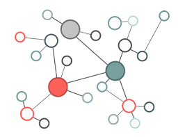 networks and identify network gaps to fill in order to be better prepared for crisis response in the future. If you have any tools you’ve used to do this or something similar, I would appreciate if you’d send them my way.”
The online discussion that followed highlighted the great advances being made in using different kinds of mapping tools. Planners, GIS and IT professionals and others have used geographic mapping tools for years and produce incredible results. But are there practical tools for other areas of government and community groups that bring the value of mapping to local problems? FPN members from across the country made ‘shout outs’ to tools. Most were simple to use and effective for their local government/community food system needs around social connections, not geography.
One type of tool is a social capital or network map. This allows you to visually show how various pieces (or people or organizations) in any process or network are connected. It is not based on physical maps – at least not initially. Imagine being able to show in one image how connections between various nonprofits are working together to provide basic needs for families affected by COVID. A single map could illustrate who is coordinating with who, such as a local charity thrift store, homeless shelter, and housing agency collaborating – helping newly evicted individuals get into a furnished place quickly. It can also show what agencies are serving as natural coordinating points. An office may be isolated in terms of knowledge and influence, and therefore less effective, because they are ‘not in the loop.’ An example of such a network mapping tool suggested by an official in Florida is Kumu.io. There are many on-line tools, but beware ones that try to do too much, hampered by complexity.
 Another example of how the network map can be used was highlighted in student research at the UNC School of Government. The elderly are one of the populations most at risk in a hurricane, yet they may resist evacuation calls. How can local officials improve the evacuation response of the elderly? Through interviews, the student, a member of the military helping enforce local evacuation orders
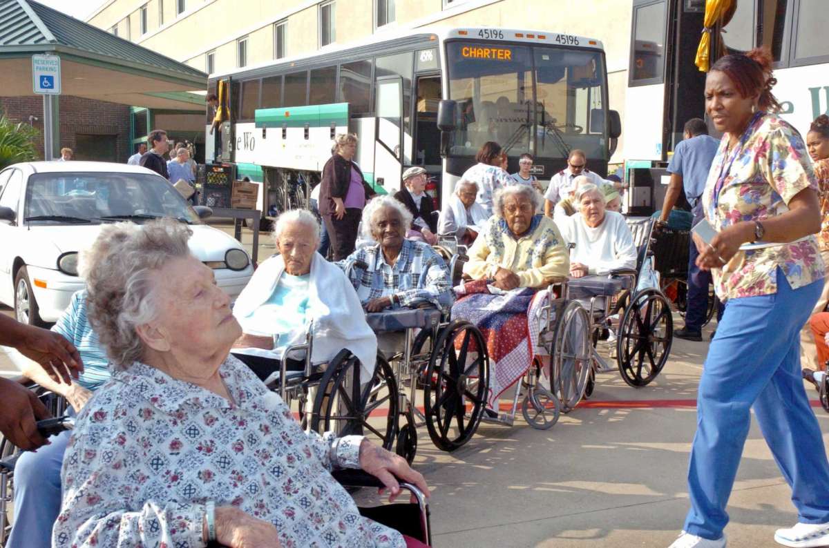 , discovered the most trusted source of information for many elderly individuals in his coastal community were faith leaders. This raised the idea of developing closer ties between the local military emergency response personnel and the faith leaders outside of the emergency, and then using phone trees and other faith organization’s informal neighbor-to-neighbor networks to get word out – words that are believed and spur action – when the emergency occurs. What appear to be most helpful are those tools where officials can import or input their own data to better understand the pattern of needs and assets, whether land, food, transport systems, or social capital relationships.
Author(s)
Tagged Under
This blog post is published and posted online by the School of Government to address issues of interest to government officials. This blog post is for educational and informational Copyright ©️ 2009 to present School of Government at the University of North Carolina. All rights reserved. use and may be used for those purposes without permission by providing acknowledgment of its source. Use of this blog post for commercial purposes is prohibited. To browse a complete catalog of School of Government publications, please visit the School’s website at www.sog.unc.edu or contact the Bookstore, School of Government, CB# 3330 Knapp-Sanders Building, UNC Chapel Hill, Chapel Hill, NC 27599-3330; e-mail sales@sog.unc.edu; telephone 919.966.4119; or fax 919.962.2707.