
|
|
|
Community and Economic Development – Blog by UNC School of Government https://ced.sog.unc.edu Student Corner: Caswell County Agricultural InventoryBy CED Program Interns & StudentsPublished November 5, 2010
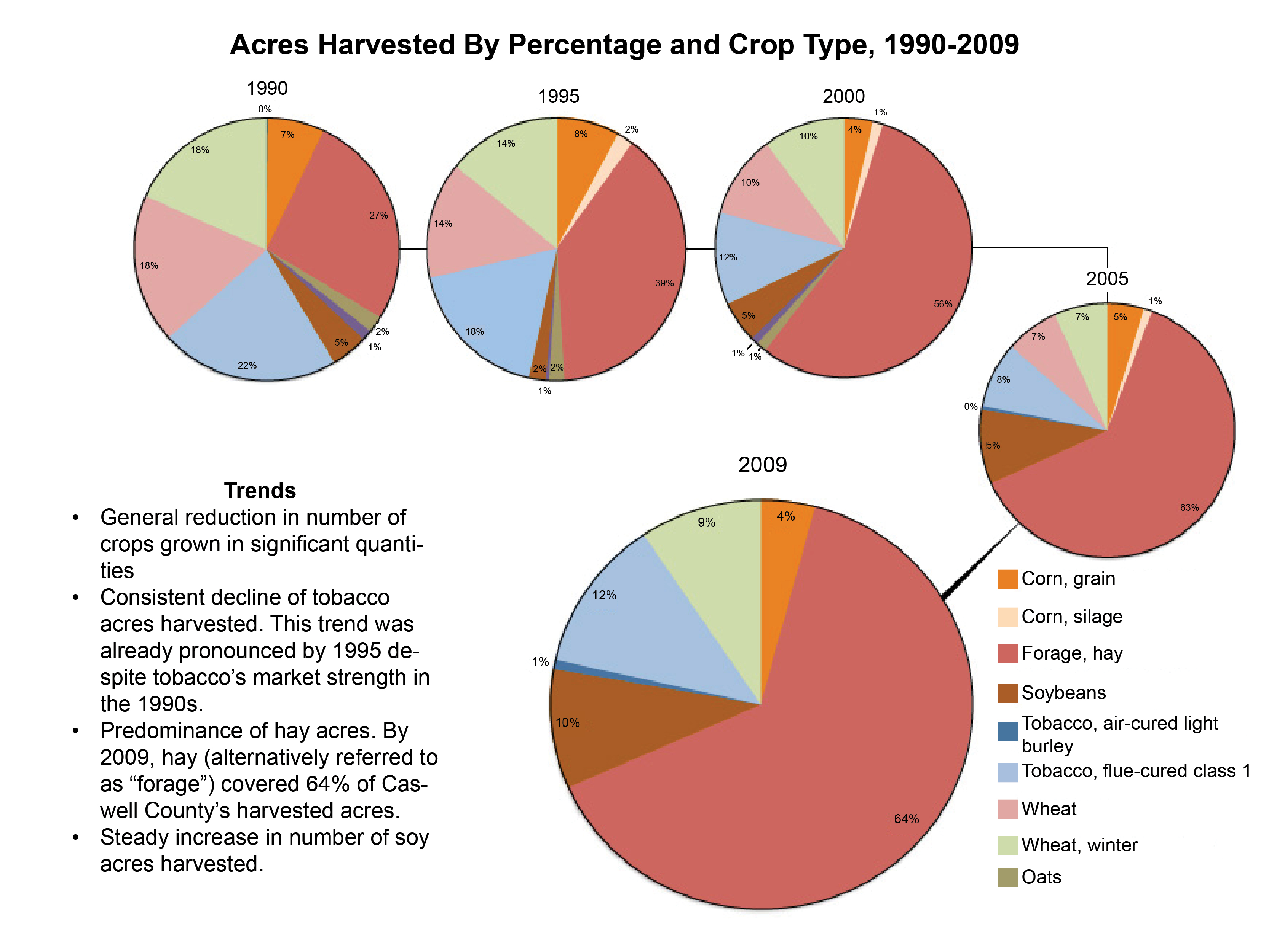
Beginning in June, CCP partnered with the Caswell Cooperative Extension Center to conduct an agricultural inventory of Caswell County (click on image for .pdf of full report). The project has resulted in a report and collection of maps that illustrate the state of agriculture in the county and attempt to identify opportunities for agriculture-related economic development. The inventory includes basic data, including annual rainfall, soils, and slopes. But it also addresses other aspects of agriculture including sector performance (compared to the central Piedmont region), crop trends in terms of acreage and value, as well as ag-related employment.The report includes spatial analysis of agricultural uses in the county, maps of agricultural land use productivity, preserved farmland, properties actively involved in Extension programming, and areas of overlap with soil quality and slopes that indicate optimal growing conditions.
The agritourism map also includes options for eating, bed and breakfasts and recreation opportunities, each of which are described in some detail on the reverse of the map with contact information, hours of operation, and any special considerations related to the site. Printed on A2, the map will be a folding guide to a day or weekend trip to the county. In terms of next steps, both Cooperative Extension and the Caswell County Planning Department have expressed a desire for assistance from with a Comprehensive Land Use Plan. As a planning document, the Caswell County Agricultural Inventory contributes a base of land use analysis to begin a comprehensive planning process. |
Published November 5, 2010 By CED Program Interns & Students
 John Killeen is a recent graduate of the UNC Department of City and Regional Planning and an intern working in Caswell County.
Beginning in June, CCP partnered with the Caswell Cooperative Extension Center to conduct an agricultural inventory of Caswell County (click on image for .pdf of full report). The project has resulted in a report and collection of maps that illustrate the state of agriculture in the county and attempt to identify opportunities for agriculture-related economic development.
The inventory includes basic data, including annual rainfall, soils, and slopes. But it also addresses other aspects of agriculture including sector performance (compared to the central Piedmont region), crop trends in terms of acreage and value, as well as ag-related employment.The report includes spatial analysis of agricultural uses in the county, maps of agricultural land use productivity, preserved farmland, properties actively involved in Extension programming, and areas of overlap with soil quality and slopes that indicate optimal growing conditions.
 A final addition to the inventory is a map intended for print and distribution at visitors’ centers and area businesses. This map details agritourism activities within Caswell County: farms that host special events, pick-your-owns, roadside stands, and other public cultural and commercial experiences. While information about many of the farms included had been publicly available before this map, much of it was several years out of date. Brief telephone surveys helped determine if they were still active farms and wished to be included.
The agritourism map also includes options for eating, bed and breakfasts and recreation opportunities, each of which are described in some detail on the reverse of the map with contact information, hours of operation, and any special considerations related to the site. Printed on A2, the map will be a folding guide to a day or weekend trip to the county.
In terms of next steps, both Cooperative Extension and the Caswell County Planning Department have expressed a desire for assistance from with a Comprehensive Land Use Plan. As a planning document, the Caswell County Agricultural Inventory contributes a base of land use analysis to begin a comprehensive planning process.
Author(s)
Tagged Under
This blog post is published and posted online by the School of Government to address issues of interest to government officials. This blog post is for educational and informational Copyright ©️ 2009 to present School of Government at the University of North Carolina. All rights reserved. use and may be used for those purposes without permission by providing acknowledgment of its source. Use of this blog post for commercial purposes is prohibited. To browse a complete catalog of School of Government publications, please visit the School’s website at www.sog.unc.edu or contact the Bookstore, School of Government, CB# 3330 Knapp-Sanders Building, UNC Chapel Hill, Chapel Hill, NC 27599-3330; e-mail sales@sog.unc.edu; telephone 919.966.4119; or fax 919.962.2707.